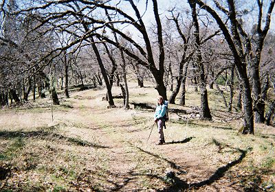
Even as my wife Joy and I were descending a very steep section of Hobbs Road, my mind was not on the task at hand. Instead, I was focused on listening to the turbulent flow of the Middle Fork of Coyote Creek, which we had soon to cross. Earlier, we had crossed the Little Fork of Coyote Creek, but had managed to do so, without taking our boots off, only after spending 15 minutes scouting the best place to cross. Normally, the creek is just what its name implies: a little fork. But this was not a normal year. Eight inches of snow had fallen at the park headquarters a week earlier and the month of March would turn out to be one of the wettest on record. Even the Little Fork was not little.
As we stood looking at the swollen creek, Joy realized that my fears about the safety of crossing it were not totally unfounded. The water was cold, moving swiftly and appeared to be about three feet deep. We reasoned that, although we could get wet and very cold if we fell in, there didn't appear to be much danger of drowning, so we should cross. We took off our boots, put on our sandals and proceeded slowly. We are both about the same height, but since Joy has better balance from her years of doing yoga, she went first. I am not a macho guy and that suited me just fine. Besides, better her wet and cold than me.
She moved cautiously, but at one point, she stepped into a big depression and the water came up about a foot above her right knee. She managed to stay upright but the digital camera in her pants pocket bit the dust. That's how things unfolded two hours into the first day of our quest to hike all the trails of Henry W. Coe State Park.
March 2006 was one of the wettest Marches on record in Santa Clara County, in which Henry Coe Park is located. It rained on 24 days of that month. The first part of April wasn't much better: it rained on 12 out of the first 16 days. Most of the county's reservoirs were full before the end of March. Coyote Creek, which flows into Coyote reservoir and then into Anderson reservoir, was a raging torrent. When full, the two reservoirs account for two thirds of the total reservoir capacity of the county. Because of concerns about the adequacy of the Coyote reservoir dam during an earthquake, the water is normally held at half the reservoir's capacity. Not this year. The authorities had no choice but to let water overflow both the reservoirs. And, at one point, water was starting to back up into Coyote Creek.
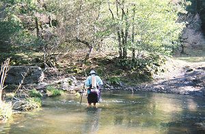
Joy crossing the Middle Fork of Coyote Creek at Hobbs Road |
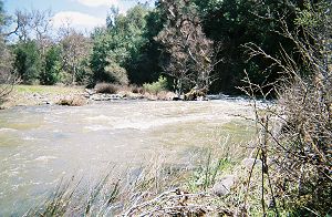
The same creek further downstream, near Poverty Flat |