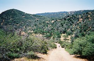
Struggling up Bear Mountain Road |
Joy wondering if that may be the last hill before the top |
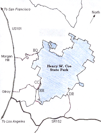
Henry Coe is a large park. It is the largest state park in northern California and second largest statewide. At 87,000 acres, it is larger than the combined land area of Palo Alto, Stanford, Mountain View, Los Altos, Los Altos Hills, Sunnyvale, Cupertino, Campbell, Saratoga, Los Gatos and Santa Clara. And, I am not making this up, even the information bulletin inside the outhouse at Mississippi Lake proclaims, besides the usual admonitions about not throwing trash into the toilet, that the park is six times as large as the island of Bermuda. In the local hiking/biking community, Henry Coe is often referred to as "Killer Coe", due to its rugged terrain and steep trails. It is also a fact that many trails shown on the map are either non-existent or extremely difficult to find. And then there are trails that are not shown on the map. In other words, a perfect park for someone looking for an adventure.
|
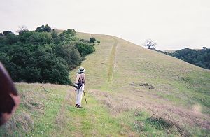
Struggling up Bear Mountain Road |
Joy wondering if that may be the last hill before the top |
We had originally planned to undertake this venture in the spring of 2004. My preliminary work had convinced me that, in order to hike the trails in the eastern part of the park, a Herculean effort would be required unless we could access the park thru Dowdy gate in the south-east corner. The other three entrances are all on the west side. However, I did not have to deal with the problem, as right around that time, Joy developed a serious foot problem, which required surgery and postponement of our plans. But, there was a silver lining to this. I learned that plans were afoot to open the Dowdy gate on a permanent basis, probably in a year or so. Since it was critical that we be able to use the entrance to enter and leave as necessary, we decided to wait two years and start our venture in the spring of 2006.
The park's web site mentions that there are 250 miles of trails. The total of all the trails shown on the 2002 park map, however, is closer to 350. Since we would have to walk many trails or their segments more than once, my initial estimate was 500 miles of hiking requiring 45 to 50 days. We set aside the three months of spring to accomplish this goal.
After weeks of poring over the maps, I eventually had a plan of action. I use the word 'maps' because, though I mainly used the 2002 park map, I needed the earlier maps to get an overall view of the park's terrain and its major trails. I doubt we would have undertaken this venture but for the amazingly detailed 2002 map. It is 30 inches by 36 inches and printed on both sides.
My plan involved doing four day hikes, each about 14 miles, from each of the four entrances and to cover approximately 40% of the total miles. Next, we would backpack and set up base camps at several interior locations and day-hike three or four trail loops from each such location. I kept the length of these loops at around 11 miles to allow time for housekeeping and finding many rarely-used trails.