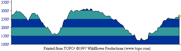
This profile shows the entire round-trip route. [ More info about elevation profiles. ]
This page describes the specific hiking route used on Mt. Sizer for Everest by the Bay.
All distances and elevations are approximate [ more info ].
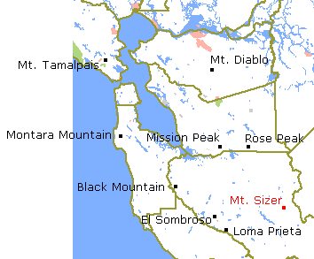
From US 101 in Morgan Hill, take the East Dunne Avenue exit and continue east on East Dunne Avenue approximately 13 miles to the park entrance. Park in the lot at the visitor center.
The route is a clockwise loop. Begin with a steep climb on Hobbs Road, then veer left onto Monument Trail. This narrow trail soon rejoins Hobbs Road, where you veer left and continue down to Frog Lake at Little Fork Coyote Creek. Here, turn right onto Frog Lake Trail. At the junction with Middle Ridge Trail, turn left. This trail also soon rejoins Hobbs Road, where you turn right. Continue down a long grade, cross Middle Fork Coyote Creek, and continue very sharply uphill on Hobbs Road (this segment is nicknamed "The Short Cut") until you reach Blue Ridge Road. Turn right and follow this road southeastward along the ridgetop to the vicinity of Mt. Sizer. Reaching the summit requires a short detour along a road to the left. Returning to Blue Ridge Road, continue on it toward the southeast. At the junction with narrow Jackass Trail, turn right onto it. This trail eventually drops steeply to Poverty Flat Road. Turn right and follow this road down to Poverty Flat. Cross Coyote Creek and continue upward on this road toward the west. On reaching Manzanita Point Road on the ridgetop, veer right onto it. At the junction with Corral Trail, veer left onto that narrow trail and return to the trailhead.
This profile shows the entire round-trip route. [ More info about elevation profiles. ]