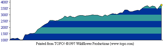
This profile shows the first half of the out-and-back route. [ More info about elevation profiles. ]
This page describes the specific hiking route used on Loma Prieta for Everest by the Bay.
All distances and elevations are approximate [ more info ].
From CA 85 or US 101, take the Bernal Road exit and go west a short distance, staying in the right lane. Take the connector to Monterey Blvd. and turn left onto Monterey. Go three miles and turn right on Bailey Ave. (There is a signal at this intersection.) Follow Bailey about two miles to a T intersection with McKean Road. Turn left and travel six miles south on McKean Road, which becomes Uvas Road along the way. Turn right on Croy Road, following the Uvas Canyon County Park sign. Continue 4.5 miles on Croy Road, passing slowly and carefully through the private lands at Sveadal, to the park entrance. Parking fees are paid at the machine at the entrance. Use the day-use parking lot on your right.
Walk along the paved road, staying to the right and crossing a bridge over Swanson Creek. After passing an information station on your left, walk left along a side road into the campground. Find the gated end of Knibbs Knob Trail between campsites 27 and 28. Follow this trail upward to a road junction at which Knibbs Knob will be on your right. (Taking the road to the right to the top of Knibbs Knob is a pleasant diversion.) Continue upward to the west, reaching the park boundary gate. Go through the gate and turn right onto Mount Madonna Road (also known as Summit Road). Caution: this public road is used by motor vehicles; hikers should stay to the left side of the road, facing motor vehicle traffic. Upon reaching a broad junction, follow Loma Prieta Road to the right and upward to a junction at the west base of the upper peak at which three roads (and one or more narrower trails) go eastward toward the peak. Here, ignore the road to the far right, which tends downhill, and take the road just to its left, which angles gently uphill along the mountain's south face. At the next junction, turn sharply left and pass through a gate in a fence. Stay to the left at any later road junctions, circling the mountain clockwise, until you reach the flat summit of Loma Prieta. Return via the same route.
Notes: Many private properties lie along Mount Madonna Road (Summit Road). You may encounter dogs running onto the road as you go by. Loma Prieta Road is privately owned, and "No Trespassing" signs are posted on the route to the summit. To my knowledge, however, hikers and bicyclists have not been denied access to the summit area. Please stay on the roads and do not touch anything other than the natural dirt, rock, and plants.
This profile shows the first half of the out-and-back route. [ More info about elevation profiles. ]