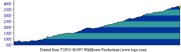
This profile shows the first half of the out-and-back route. [ More info about elevation profiles. ]
This page describes the specific hiking route used on Mt. Diablo for Everest by the Bay.
All distances and elevations are approximate [ more info ].
Exit Interstate 680 in Danville onto Diablo Blvd and go east. Turn left onto Mt. Diablo Scenic Blvd. Proceed about 0.8 miles. Driving slowly, look for the State Park boundary. Just beyond, you will see a small dirt strip for parking on your right and the Summit Trail trailhead on your left. (Note: As of May 2010, parking is no longer allowed near this trailhead.)
Follow Summit Trail from the trailhead to the summit, and return along the same route.
This profile shows the first half of the out-and-back route. [ More info about elevation profiles. ]