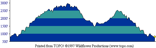
This profile shows the entire round-trip route. [ More info about elevation profiles. ]
This page describes the specific hiking route used on El Sombroso for Everest by the Bay.
All distances and elevations are approximate [ more info ].
From Highway 17, take the East Los Gatos exit. At Los Gatos Blvd., turn left. After less than 0.3 miles, turn right on Kennedy Road. Go about two miles and turn left onto Top of the Hill Road. There is curbside parking on this street. The trailhead is on the other side of Kennedy Road.
Follow Kennedy Trail up past its junction with Priest Rock Trail to the junction with Woods Trail and Limekiln Trail. Continue on Woods trail to an unsigned power line service road on the left (about half a mile from the junction of Kennedy and Woods Trails). The road dips slightly to a clearing and ends. The summit area is reached via a short unmaintained trail through the brush to the left. (Note: this unmaintained trail, really just a track, is guarded by treacherous tendrils of poison oak on the ground, to each side, and hanging from branches overhead. Sometimes it's just not really necessary to reach the actual summit, is it?) Return to the junction of Woods Trail and Limekiln Trail, and follow Limekiln Trail to the left and downward. Upon reaching Priest Rock Trail, follow it up to the right to its junction with Kennedy Trail. Turn left and return to the trailhead.
This profile shows the entire round-trip route. [ More info about elevation profiles. ]