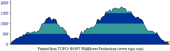
This profile shows the entire round-trip route. [ More info about elevation profiles. ]
This page describes the specific hiking route used on Montara Mountain for Everest by the Bay.
All distances and elevations are approximate [ more info ].
The trailhead (marked "McNee Ranch") is on Highway 1 at the foot of the first small hills just north of Montara State Beach, which is itself just north of the town of Montara. There is room for a few vehicles at the trailhead on the east side of the highway. More parking is available in the state beach lot, to the south on the west side of the highway.
Follow the unnamed trail (not the road next to it) which, after a while, travels northward, up, with the ocean in full view to your left. Turn right at a large unmarked post in the middle of the trail (less than half a mile from the start) which cuts across the small ridge and down to (unsigned) Old San Pedro Road, where you turn left. At the junction with Montara Mountain Road, follow it to the right and sharply upward. On reaching the narrow Montara Mountain Trail at a signpost on the north shoulder of the mountain, turn left and descend on it to San Pedro Valley Park Visitor Center (rest rooms, water). Then follow Brooks Creek Trail upward to its junction with Montara Mountain Trail, and ascend on it, returning to Montara Mountain Road. Turn left and ascend to Montara Mountain's North Peak. Return via Montara Mountain Road and Old San Pedro Road. On reaching a road descending to the left directly towards the ranger residence, follow it to the trailhead.
This profile shows the entire round-trip route. [ More info about elevation profiles. ]