A study in contrast: Eureka Dunes and Last Chance Mountains
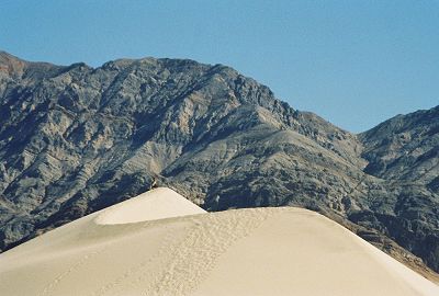
Rising 700 feet above the surrounding Eureka Valley, these are the tallest dunes in California. The Great Sand Dunes in Colorado have the distinction of being the highest in North America. But, they are only about 50 feet taller than Eureka Dunes. Sand dunes are constantly shifting, and as such, their height, as well as the area they cover, are not exact. Eureka Dunes are tucked away in the northern part of Death Valley National Park, about a two and a half hour drive from the visitor center.
I picked the middle of March to visit this and the other desert dunes. I reasoned that we would have about 12 hours of daylight and that the daytime high temperatures would still be in the high seventies or the low eighties. My main concern was the amount of water we would need to carry for an all day romp in the dunes. There was no way to replenish our water supply during the day. To be safe, we each planned to carry a gallon of water.
We arrived at Eureka Dunes just before 9 A.M. on a bright, sunny day. Even though we had been there before, the first sight of the tall dunes took our breath away. It was really amazing to realize that the shining sand mountain in front of us was once an ancient lake bed. How sand dunes are formed is quite complex, but in a nutshell, they are formed when wind carries loose sand particles and deposits them in an area devoid of much vegetation, such as a dry lake bed. Why certain dunes are so tall is still not fully understood.
A study in contrast: Eureka Dunes and Last Chance Mountains
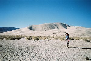
These dunes are tall, but not massive. They occupy only about three square miles. Most visitors park in an area where there is a bulletin board and a few picnic tables. They then make a beeline for the top and return the same way. This may take an hour or two. We had a more ambitious plan. We wanted to start at one end of the dunes and traverse the entire area. We drove further on a sandy road till we came to a pullout. We parked the car, took a GPS reading of the position of our car and set out to climb the long ridge that would take us to the high point. As we made our way up the ridge, I noticed that I was sweating profusely. Yes, we were climbing a steep ridge, but it was not even ten o'clock yet. The weather forecast was for an unseasonably warm week throughout the desert. Unlike the central part of Death Valley, which is mostly below sea level, the base of the dunes is at an elevation of almost 3,000 feet. Thus, the temperature at the dunes should be about eight to ten degrees F lower than that in Death Valley. Unfortunately, the sun's rays bouncing back from all that sand appeared to negate any such reduction.
Hurry up; I want to get going |
Just how long is this ridge? |
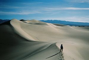
We walked gingerly on the ridge to avoid slipping back or sliding sideways on the steep and slippery side slopes. Regardless, it was a very enjoyable ridge walk. There is something exhilarating about walking on a knife edge ridge where the sides fall off precipitously. When we reached the high point, I checked my GPS and it showed that the top was just about 700 feet above our car.
Come on, you slowpoke. I already broke the trail for you.
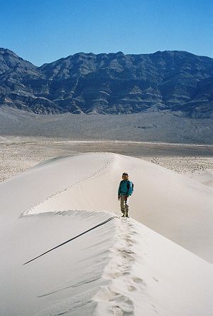
After a brief rest, we continued on the ridge. After a descent of 100 feet, we climbed back up to another high point, which was about 20 feet lower than where we had come from. Then we started descending in earnest. Then, we would climb back up again. After about three hours, we came to a plateau and decided to stop for lunch. It was a little after noon and we had covered maybe three miles, with a mile still to go to reach the far end of the dunes. We had plenty of time, but our water situation was a little grim. We had already consumed over five quarts, and between the two of us, we now had only two quarts of water and half a bottle of gatorade. The hottest part of the day was still ahead of us. Reluctantly, we decided to return to our car, rather than risk the serious consequences of dehydration. On the way back, we walked around the high ridge and returned to our car in about two hours.
Even though Death Valley Road is dirt and rocks for more than 40 miles, we felt at ease. We had driven the road several times in the past. Unfortunately, we hadn't gone more than 500 feet beyond a spot known as Crankshaft Junction when we had a flat tire. This area, as it name implies, has been notorious for damaging vehicles. Several years ago, in the same general area, a friend of ours had a flat too. Well, we didn't have a flat; we had a blowout. The tire was completely shredded and the rim was bent. I was tired after walking the dunes and didn't relish the thought of changing the tire in what seemed like 90°F weather. But I had no choice. We were literally in the middle of nowhere. There was no cell phone reception and no cars in sight. I had a hard time loosening one nut, and for a moment, I wondered if we might not have to spend the night right there on the road. But we were not worried; we had with us all our camping gear, food, five gallons of water and even a satellite phone. We put on the new tire and proceeded cautiously on the dirt road to our destination, the motel at Stovepipe Wells.